What is Geomatics

Geomatics SketchThis is a brief description,

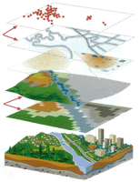
Geomatics engineering is a rapidly developing discipline that focuses on spatial information (i.e. information that has a location).

The term is thought to be developed by B. Dubuisson in 1969 from the combination of GEODESY and GEOINFORMATICS terms.

Geomatics is a new term incorporating the older field of surveying along with many other aspects of spatial data management. Following the advanced developments in digital data processing, the nature of the tasks required of the professional land surveyor has evolved and the term surveying alone does not any more describe the whole range of tasks that the profession deals with.

As our societies become more complex, information with a spatial position associated with it becomes more critical to decision-making, both from a personal and a business perspective, and also from a community and a large-scale governmental viewpoint.


Geomatics engineering APPLICATIONS include integrating science and technology from both new and traditional disciplines:
•    Geodesy, also called geodetic science
•    Cartography, computer and digital mapping
•    Remote sensing, LIDAR, Photogrametry
•    Land information systems (LIS)
•    Real Property boundary determination
•    Hydrograph, navigation, topographic and spatial computing
•    Land, cadastral, aerial, mining and engineering Surveying
•    Construction layout, route design
•    Image understanding and computer aided visualization
•    Computer-aided design (CAD)
•    Geographic information systems and science(GIS)
•    Satellite Positioning Systems (GPS, GNSS)
•    Applications programming
•    Project management


Geomatcs
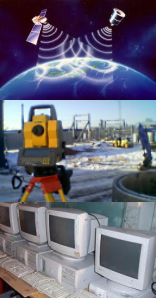
Geomatics engineers serve society by collecting, monitoring, archiving, and maintaining diverse spatial data infrastructures.

Geomatics engineers utilize a wide range of technologically advanced Tools, which enable the Geomatics engineer to gather, analyze, and manage spatially related information to solve a wide range of technical and societal problems.


These facts demonstrate the breadth, depth and scope of the highly interdisciplinary nature of Geomatics engineering.